The oil and gas industry in Pakistan offers a promising environment for energy companies. Pakistan has set up strategic areas, rules, and benefits for companies that explore and produce oil and gas (E&P). These policies are designed to make things easier and to bring in more foreign money. Let’s look at the different areas, how companies get permission to work there, and the good deals available in Pakistan’s oil and gas industry.
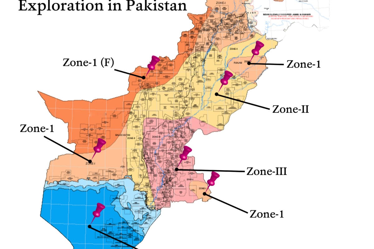
Zoning for Onshore and Offshore Oil and Gas Exploration
Pakistan has divided its onshore and offshore areas into different categories based on the geological risks and the amount of investment needed:
- Onshore Zones:
- ZONE-I and ZONE-I(F): High-risk, high-cost areas with significant geological challenges.
- ZONE-II: Moderate risk with high to medium cost requirements.
- ZONE-III: Low risk and low cost, making it more accessible for E&P activities.
- Offshore Zones:
- Shallow (up to 200m): Easier to access with lower risks.
- Deep (200-1000 m): Moderate accessibility and higher technical challenges.
- Ultra Deep (Beyond 1000m): High-risk, high-investment areas with potentially large rewards.
This organized zoning helps companies assess the balance between risk and reward in each area, guiding their strategies according to geological and financial considerations.
Concession Award Process for E&P Rights
Pakistan’s upstream sector provides three procedures for granting E&P rights:
- Competitive Bidding:
Petroleum Exploration Licences are given for both land and sea areas. Companies try to win these by using Work Units, a new idea that lets them change their plans to get the best results.
- Government-to-Government Agreements:
Companies that work closely with the government can get the right to explore new areas without having to compete with others. This helps build strong relationships between the government and these companies, and it also benefits both sides.
- Reconnaissance Permits:
For businesses that conduct research and surveys, non-exclusive licenses can be acquired through direct talks, allowing them to gather data from multiple sources.
Invitation to Bid: Transparency in the Bidding Process
To guarantee a fair and clear process, the Directorate General of Petroleum Concessions (DGPC) publishes public invitations for companies to submit their bids. These bids are open for at least 60 days, giving enough time for interested companies to join. The process favors companies that offer the most Work Units. If several companies offer the same amount, they can submit new bids to make the competition more equal.
Agreement Execution for E&P Activities
The DGPC helps make it easy and fast to sign Petroleum Concession Agreements (PCA) or Production Sharing Agreements (PSA) using standard templates. This organized process reduces paperwork and delays, so companies can start their exploration work as soon as possible.
Gas Market Access and Infrastructure
E&P companies have permission to build and run pipelines for both local use and exporting. The gas market works with an open-access system, where companies with solid plans get priority. The building of pipelines follows the government’s energy plan, and the prices are controlled by the right groups, making sure companies make money while also looking out for the public’s needs.
Investment Incentives: A Favorable Onshore Package
Pakistan’s onshore oil and gas exploration package has several benefits to encourage foreign investment:
• Royalties: A standard 12.5% royalty on the value of petroleum produced is applied. This gives the government a fair share while keeping costs reasonable for companies.
• Corporate Income Tax: The tax on profits is capped at 40%, and royalty payments can be deducted as expenses. This makes Pakistan a good choice for large oil and gas companies.
• Local Partnership Requirement: Foreign companies must partner with local firms, like GHPL. This helps local businesses grow and allows international expertise to enter the market.
• Production Bonuses and Work Units: Companies get bonuses based on how much they produce, and Work Units allow for flexible work requirements. This helps companies adjust their plans based on the actual conditions they find.
Import Duties and Taxes
The rules for taxes provide significant benefits for companies doing oil and gas work:
- Imported equipment that isn’t made locally has a 5% import tax, while locally made items have a 10% tax, and wellhead equipment has a 15% tax.
- Companies that provide technical services to oil and gas firms don’t have to pay import duties, sales tax, or license fees, which lowers their costs.
Social Welfare and Training Contributions
Acknowledging the significance of community well-being, the rules require oil and gas companies to make social and training payments:
- Training Payments: These companies pay yearly, with $25,000 during the search for oil and gas and $50,000 during the building phase.
- Social Welfare Payments: Depending on how much oil and gas they produce, companies fund local welfare projects, helping communities in areas where they search for and produce oil and gas.
Key Takeaways
Pakistan’s oil and gas industry is set up to bring in investments while considering economic, environmental, and social needs. By using a system of zones and competitive offers, along with government help and benefits, the country makes it easier and more profitable for companies to find and produce oil and gas.
For more details, refer to the Petroleum (Exploration and Production) Policy 2012.